Jose Francisco
Nuñez Obando
Consultant
Data Analyst, Geographer, Cartographer & Digital Designer
Academic Studies
Student in M.Sc. in Computer Science from Instituto Tecnologico, Costa Rica. Postgraduates Degree in Data Analyst, Universidad Cenfotec, Costa Rica. Skills to collect, process and manage data, from the integration of knowledge in data-oriented programming (Python, R, SQL), big data, data analysis, data visualization and statistics, with the aim of generating value for decision-making. Licentiate´s Degree in Geographic Sciences, Universidad Nacional de Costa Rica. The goal of the geographical sciences is the study of the phenomena and territorial processes, which are focus in the physical geography, the social geography and the territorial analysis. It is the science that deals with analyzing man's relationships with his natural environment, identifies and characterizes sections of space (territory, regions, landscapes and locations). This allows to offer specific methods and analytical techniques to respond to the problems of ordering the territory. Associate´s Degree in Cartography & Digital Design, Universidad Nacional de Costa Rica. Cartography constitutes a fundamental instrument for the communication of spatial information and decision-making. The cartography requires knowledge, integration and application of different basic and instrumental disciplines, in particular mathematics, geostatistics, photointerpretation, applied geomorphology and geographic information systems.
Experience
Professional with experience in geographic research, conservation, landscape, thematic mapping, geographic information systems, quantitative and qualitative analysis, databases, programming languages for data analysis (Python, R), SQL, HTML, knowledge of Machine Learning, Jupyter Notebook, ETL software, Big Data, teaching and training, Interactive Data Visualization BI (Power Bi, Tableau, Oracle Data Visualization, Google Data Studio, others), graphic - web design and diagramming, among other works carried out in different institutions and companies, both national and international, including: UNICEF, Universidad Nacional, Conservation International, MEP, European Union, Kus Kura S.C., Plan Regional y Urbano de la Gran Área Metropolitana (PRUGAM), Triada Research and Planning, Prospectiva - Top Box Research, Color Vision, International Student Volunteers, Biocenosis Marina, PRETOMA, others. Co-author and speaker on various scientific research relating to the conservation of natural and cultural heritage.
Areas: Biogeography & Biology, Environment & Geophysics, Culture & Conservation, Planning & Territory, Geomarketing & Interactive Data Visualization
Gallery
Examples from different projects.
UNICEF
“Design of Geographic Information System and Thematic Atlas for the follow-up of the obtained results in the “CON VOS” and “YO ME APUNTO” programs of the Ministerio de Educacion Publica de Costa Rica”.
Biocenosis Marina
"Support for the Establishment and Implementation of Responsible Fishing Marine Areas, Based in Planning Instruments Developed through a Participatory Process".
Universidad Nacional
Graphic design of cover and back cover and diagram of the "Memory: Symposium of Urban Ecology and Landscaping".
Portfolio
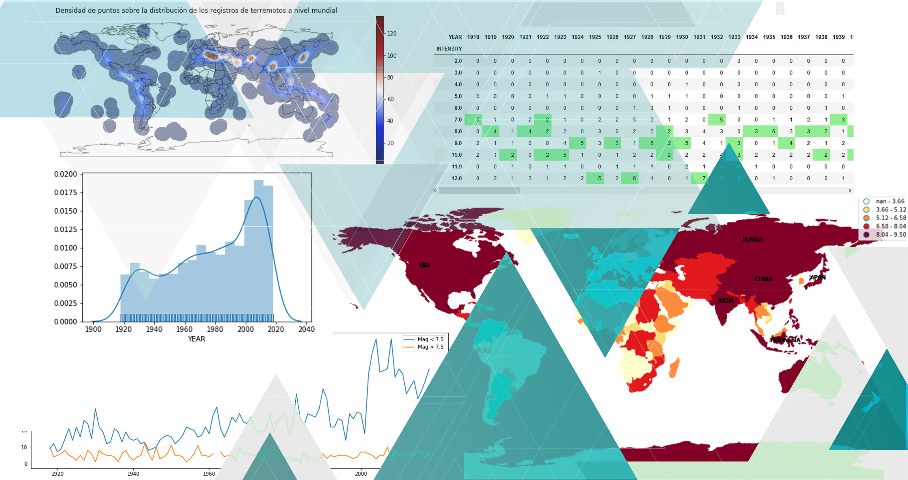
Data Stories (Samples in Spanish & English).
Get in touch
Contact through:
© Jose Francisco. All rights reserved. Template: HTML5 UP.